YUSHU:
The capital city of Southern Qinghai Tibetan area, 3700 meters
above sea level. It is surrounded by mountains over 5000 meters
high. Many Tibetan structures on the mountainsides. Horse
- racing is popular.
THE TEMPLE OF PRINCESS WENCHEN:
A Tang- style temple built in memory of Princess Wenchen of
Tang Dynasty times.
BAYANGELA MOUNTAIN PASS: The
watershed of Yangtze and Yellow Rivers, 4900 meters above
sea level. From a temple constructed on the pass, one can
see the networks of the Yangtze and Yellow rivers.
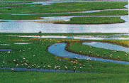
HEADWATERS OF THE YELLOW RIVER:
100 kilometers along the highway to the west are the headwaters
of the Yellow River. It is an ancient basin 4500 meters above
sea level, cluttered with 170 lakes.
 ZHANIN
LAKE AND ENIN LAKE: Two big lakes formed near the
source of the Yellow River. Zhanin is 526 square kilometers
and Enin is 610. The distance between these two is 20 kilometers.
They are linked by the Yellow River with an average depth
of 18 meters. Fish are abundant in the lakes. The Tubo King
Shungzhanganbu net Princess Wenchen here during the Tang
Dynasty period.
HUASHI
GORGE -- AMINGMAGIN MOUNTAIN: A snow mountain on
the East part of Kunluan mountains, the main peak is 6280
meters high. Glaciers spill off the slopes. A holy mountain
of Tibetan Buddhism. Tourist groups are welcome all year
long.
THE GREAT GONGHE PRAIPIE:
The Yellow River flows to Gonghe Basin after passing through
1000 kilometers of steep mountain valleys. The basin is
3000 meters above sea level. The prairie is the main base
of Qinghai animal husbandry.
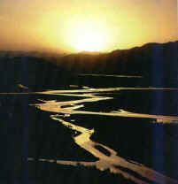
LONG YANG GORGE: Both a big
power station and a big reservoir in the Yellow River Valley
. The dam is 178 meters high, the water containment is 24.7
billion cubic meters.
THE SUN
AND MOON MOUNTAIN: A mountain by the side of Qinghai
lake,4877 meters high, it is the agricultural demarcation
line of Qinghai Tibetan Area and the only route of the Tang
Qing Ancient Road and the Silk Road.
THE BACKFLOWING
RIVER: "All rivers flow east , only this one turns
west ." It flows into Qinghai lake.
THE
RELICS OF FU GUANG CITY: The capital city and political
center of the 6th century Tungukuen Kingdom. It was destroyed
in 1591.
The best season is from April
to December.
|